Oct 21, 2026
Drone Detection Radar: X-band vs mmWave Guide
Drone detection radar buyer's guide: compare X-band vs mmWave, check CL-R8000 RCS-based ranges, and use seven procurement checks. Request a site coverage plan.
No counter-drone system works until it answers one question first: where is the UAV? At night, in fog, or across a two-kilometer perimeter, drone detection radar is the primary all-weather sensor that answers it — and the track it produces is what most effectors cue from. But radar is rarely alone: professional sites fuse it with RF detection and EO/IR cameras, because each sensor answers a different question.
This guide covers how drone detection radar works, why X-band site radar and millimeter-wave onboard radar are different product categories, the specifications worth demanding in a tender, and the range claims that look impressive on a datasheet but collapse in the field.
How Drone Detection Radar Works
A counter-drone radar transmits radio pulses and analyzes the echoes that return from small aerial objects. What separates it from general air-surveillance radar is that it is purpose-built for low, slow and small (LSS) targets:
- Tiny radar cross-sections (RCS). A consumer quadcopter may present only 0.01 m² of reflective area — on the order of a large bird. The radar must separate it from ground clutter without drowning the operator in false alarms.
- Slow, low flight. Targets cruise at 5–30 m/s, often below 120 m altitude in civil airspace, against a background of buildings, trees and terrain. Rogue or military-grade drones may fly higher and faster.
- All-weather operation. Radar is unaffected by darkness and far less affected than cameras by fog, rain, smoke and dust — though heavy precipitation and dust still degrade performance and raise clutter.
- Track output, not just a detection alarm. A useful radar reports azimuth, range, altitude and velocity on each scan and feeds that track to a command platform that cues effectors.
Many long-range systems use a pulse-Doppler, three-coordinate architecture: Doppler processing filters stationary clutter, while the three-coordinate design resolves the target's position in azimuth, range and height.
X-Band vs Millimeter-Wave: Two Different Product Categories
Buyers often compare these as alternatives. They are not — they solve different problems at different ends of the mission.
| X-band site detection radar | Millimeter-wave onboard radar |
|---|---|---|
Primary job | Wide-area airspace surveillance | Ranging, obstacle avoidance, altitude hold |
Mounted on | Ground, vehicle or mast | The UAV itself |
Typical range | Several kilometers | Centimeters to tens of meters |
Output | Target track (range, azimuth, altitude, speed) | Distance to obstacle or ground |
Buyer | Site security, air defense, integrators | UAV makers, survey and inspection operators |
The simplest way to remember the split: X-band radar watches the sky; millimeter-wave radar watches what is in front of the drone. If your requirement is "detect an intruding UAV before it reaches the fence," you are buying X-band. If your requirement is "keep my UAV from flying into a wall or landing hard," you are buying onboard millimeter-wave sensors — and the operating band and range depend on the specific module, not on a single industry standard.
Chenlong's onboard line illustrates the range: the MR72-UAV avoidance radar is a 77 GHz double-beam unit measuring 0.2–40 m; the UAM231 fan-beam altimeter measures height below the platform; and the NRA24Pro altimeter is specified at 2 cm measurement accuracy. Each datasheet should be read on its own terms.
What a Credible Specification Sheet Looks Like
Many vendor pages lead with one number — detection range — and bury the conditions behind it. Below is a published example from Chenlong's CL-R8000 X-band drone detection radar, with the parameters that actually determine whether it fits a site.
Parameter | CL-R8000 published value |
|---|---|
Radar type | Pulse-Doppler, three-coordinate |
Frequency band | X-band, 9–10.2 GHz |
Detection range — small consumer quadcopter | >8 km at RCS 0.01 m² (DJI Phantom 4 class) |
Detection range — larger small UAV | >10 km at RCS 0.1 m² |
Azimuth coverage | 0°–360° mechanical scan |
Elevation coverage | 0°–30° phase scan |
Range accuracy | ≤10 m |
Azimuth accuracy | ≤0.5° |
Elevation accuracy | ≤0.5° |
Range resolution | ≤20 m |
Azimuth resolution | ≤2.5° |
Elevation resolution | ≤4° |
Velocity range | 1–80 m/s |
Near blind zone (upper bound) | ≤200 m |
Simultaneous target capacity | ≥200 |
Tracking mode | Track-while-scan (TWS) |
Track output | UDP |
Three details in that table matter more than the headline range.
First, the range is quoted against a stated RCS. 0.01 m² and 0.1 m² are the essential first condition for any honest comparison. A vendor claiming "10 km" without naming the target size is telling you nothing.
Second, the near blind zone is an upper bound, not a feature. ≤200 m means targets inside that radius may go undetected; confirm the actual minimum detection range and plan overlapping coverage for the gap. Effectors have their own minimum ranges too.
Third, accuracy and resolution are not the same thing. Accuracy is how close the reported position is to the truth; resolution is the ability to separate two nearby targets. At 5 km, a 0.5° azimuth accuracy corresponds to roughly 44 m of cross-range uncertainty, while azimuth resolution of ≤2.5° means two drones closer than about 220 m in azimuth may merge into one track. If you plan to hand a track to a narrow-beam effector, ask for both numbers — plus the track update rate.
Detection, Identification and Engagement Range Are Not Interchangeable
Range figures get mixed up constantly in tenders. Keep the three layers separate:
Layer | What it answers | Typical range (published examples) |
|---|---|---|
Detection | Is something there, where and how fast? | X-band radar: >8–10 km (RCS-dependent) |
Identification | What type of drone, and where is the pilot? | RF spectrum: ≥5 km in open terrain |
Verification / engagement | Can I see it clearly, and can I stop it? | EO/IR and effectors: closer, line-of-sight dependent |
A site with 10 km detection and 1 km engagement is not over-specified — it is buying warning time. What matters is that each layer is sized deliberately rather than compared as if the numbers were the same measurement.
Seven Procurement Checks
- Range against your actual threat class. A racing drone and a DJI Phantom do not present the same echo. Require the RCS assumption in writing and ask what range holds for the smallest drone you expect.
- Coverage geometry. 360° azimuth is not the whole story. A 0–30° elevation fan covers low-altitude approach well — at 8 km, 30° reaches roughly 4.6 km of altitude — but steep diving or high-angle approach close to the radar may need different mounting or a second unit.
- Angular accuracy and resolution. Both matter for narrow-beam handoff, as calculated above. Ask for the track update rate in Hz as well.
- Target capacity, update rate and false-alarm performance. A capacity of 200+ simultaneous tracks matters for swarms. Ask how the radar behaves when the count is exceeded, and request field false-alarm data — published figures vary widely by environment.
- Integration surface. "UDP output" is a transport, not an interface. Ask for the message schema, ICD, field definitions, latency, coordinate and time reference, and cybersecurity provisions before promising an automated engagement chain.
- Regulatory and environmental fit. Spectrum licensing, type approval and airport frequency coordination are hard gates for airports, prisons and military sites. Ask for power consumption, ingress protection (IP) rating, operating temperature and MTBF — if they are not published, put them in the RFP.
- Deployment mode. Fixed mast, vehicle-mounted or rapidly redeployable. A border or mobile military unit usually needs vehicle mounting; a substation may only need a fixed tower.
For integrators, add one more paragraph to the RFP: ICD, SDK/API access, protocol documentation, firmware support policy and certification evidence.
Radar Alone Is Not Enough: The Sensor Layer
Radar answers "where," but not "what." Pairing it with the other two sensor families closes the gap.
Sensor | Strength | Limitation | Best role |
|---|---|---|---|
X-band radar | All-weather, long range, altitude and velocity | Cannot identify drone type; birds and clutter require filtering | Primary detection and tracking |
RF / spectrum detection | Identifies drone model and locates the operator; passive | Blind to autonomous or fiber-optic drones with no RF link | Identification and pilot location |
EO/IR camera | Visual confirmation and evidence recording | Degraded by fog and rain; IR restores night capability but not visibility through heavy weather | Verification before engagement |
Chenlong's S5000+ spectrum detection system shows what the RF layer contributes: 300 MHz–6 GHz coverage, a detection radius of ≥5 km in open terrain for drones transmitting above 0.1 W with 10 MHz bandwidth, 360° azimuth and ≥1,000 m altitude coverage. Single-station AOA direction finding is specified at ≤3° RMS; adding TDOA requires at least three stations spaced ≥500 m apart, which locates the drone to within 30 m inside the network and 100 m outside it. That pilot-location capability supports interdiction and evidence collection, not just detection.
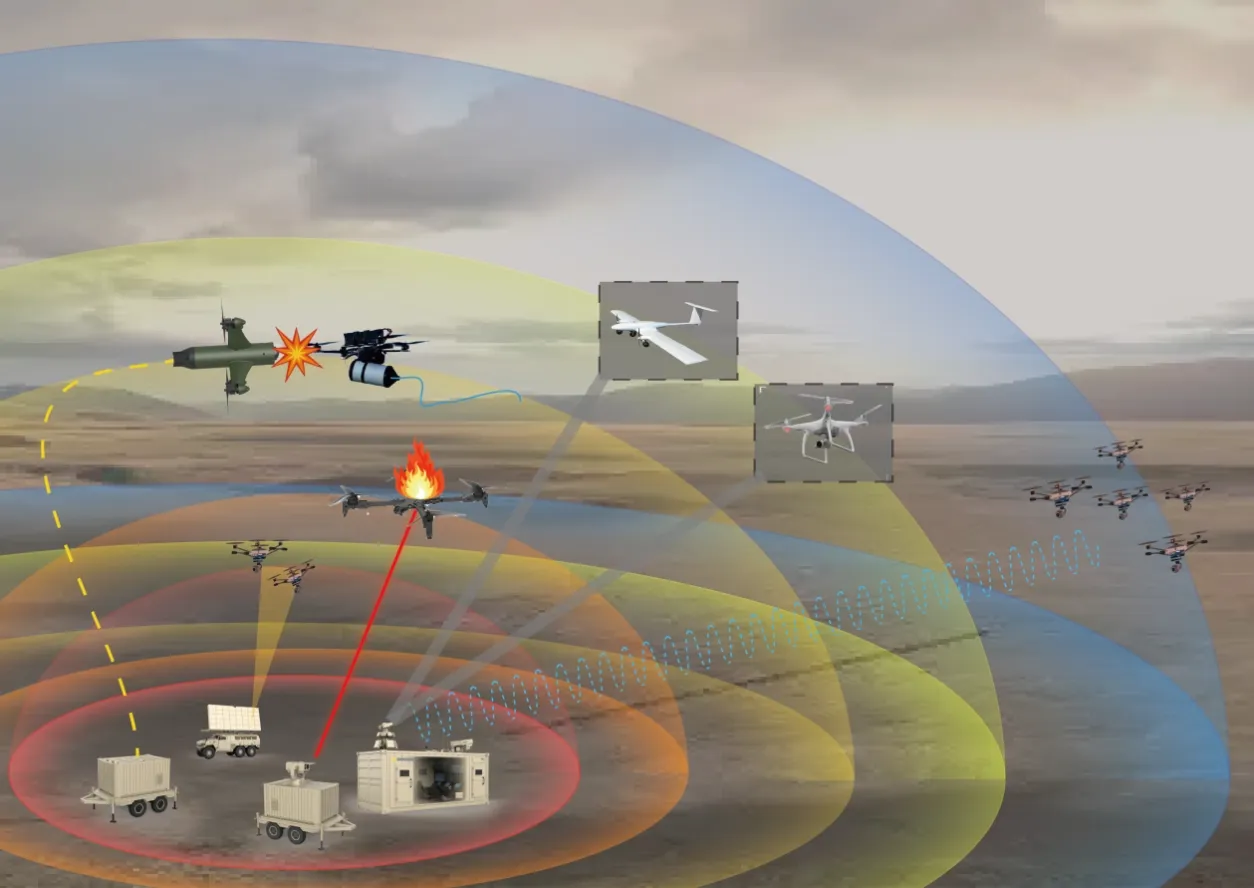
For the full detect-to-engage chain, see how the anti-drone system works together. For the engagement layers beyond detection, read our guides to jammers and handheld counter-drone guns and laser anti-drone systems.
Where Drone Detection Radar Is Deployed
- Airports and airfields — detection along approach corridors, where a single incursion can close a runway.
- Energy and industrial sites — oil fields, refineries, power plants, substations and dams.
- Prisons and correctional facilities — perimeter coverage against contraband delivery flights.
- Government buildings and landmarks — continuous early warning with discreet siting.
- Large events — portable radar for stadiums and temporary venues; jamming only where legally permitted and operated by authorized agencies.
- Military bases and defense facilities — fixed or vehicle-mounted perimeter coverage, cued to effectors under operator authorization.
Counter-UAS (C-UAS) deployments are subject to local spectrum, aviation and law-enforcement rules. Detection is generally the least restricted layer; jamming and laser engagement are tightly regulated in most jurisdictions and should only be operated by authorized agencies.
Drone Detection Radar FAQ
How far can drone detection radar detect a small drone?
Professional X-band counter-drone radar detects consumer-class drones at several kilometers. The CL-R8000 above is specified at >8 km against a 0.01 m² target and >10 km against 0.1 m². Always confirm the radar cross-section and test conditions behind any range claim.
Can radar work at night or in bad weather?
Yes. Radar is independent of light and far less affected than optical sensors by fog, rain, smoke and dust, though heavy precipitation and dust reduce performance. That is why radar anchors the sensor layer while cameras verify.
Does radar identify which drone it is?
No. Radar provides position, altitude, speed and course where the track output supports it. Identification requires RF/spectrum detection, which reads the control and video links, and EO/IR cameras for visual confirmation.
Can radar automatically cue jammers or lasers?
Yes, if the radar publishes a documented track schema that the command platform can consume, and the engagement remains under operator authorization. A radar that only displays tracks on its own screen cannot feed an automated chain.
Do I need one radar or several?
It depends on perimeter shape, terrain masking, the near blind zone and elevation requirements. Long, non-line-of-sight perimeters usually need multiple units with overlapping coverage; compact sites often need one.
Design Your Detection Layer with Chenlong
Chenlong supplies an integrated sensing layer — X-band drone detection radar, RF spectrum detection, electro-optical tracking cameras and millimeter-wave radar for UAV platforms. Send us your site layout and threat profile and our engineers will propose a detection configuration with coverage analysis. Test reports and detailed specifications are available under NDA for qualified projects.
All Chenlong international sales are conducted in accordance with applicable Chinese and destination-country export control regulations, and supplied only to vetted, eligible buyers. Export licenses and end-user/end-use certificates may be required; no re-transfer without authorization. Specifications are subject to change.